T4.14 IT Traffic Network Optimization

Overview/ summary

The purpose is the will to optimize the existing road traffic network

We want to reach the target, working in 3 different chapters.

1)  Chapter 1: we want to built a dense network of sensors to permit us to know the traffic situation in real time, for all the core corridors of the country.

2)  Chapter 2: we want to achieve ad manage data

3)  Chapter 3: the third part consist in building an “user interface” for sharing data and information to our system-partners, for the optimization of the road traffic network


NETWORK CONSTRUCTION
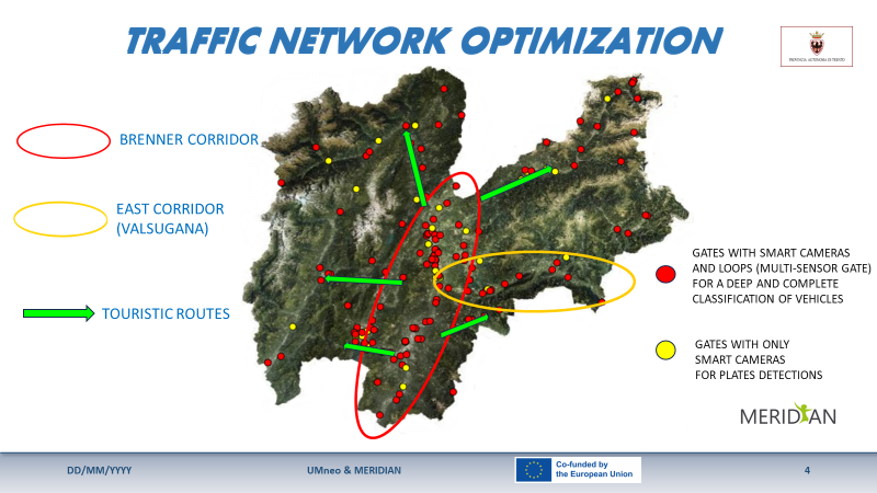
We want to built the “core information system” using two different kind of sensors in a basic network of (about) 135 gates:

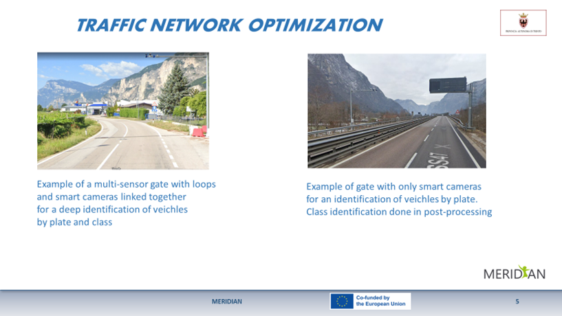
1)  The old and solid technology given by loops and counters, that is still perfect for a very accurate classification of vehicles

2)  The new technology of “smart cameras”, that read and (and encrypt) plates of vehicles, that is very good and chip for reading plates

Linking these two technologies, in these gates we have the maximum results, because a class can be linked forever with the plate. So, if in many others gates, the network is only provided by smart cameras, the class is obtained “via software” because the link was already obtained in one of the gates of basic network

SOFTWARE
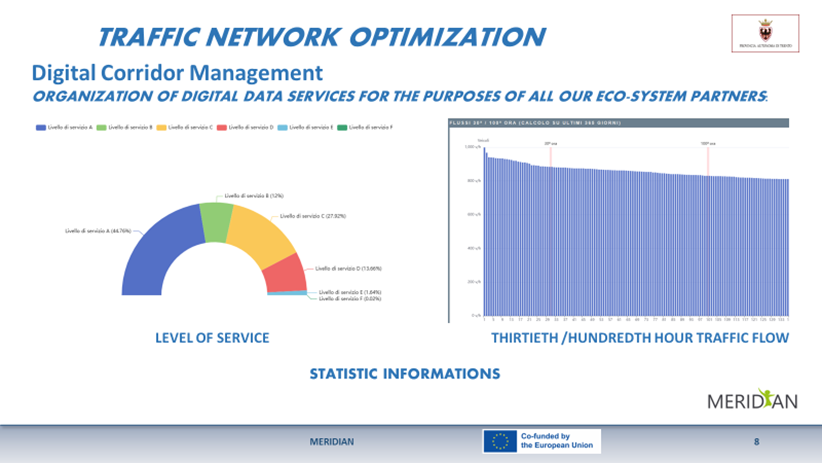
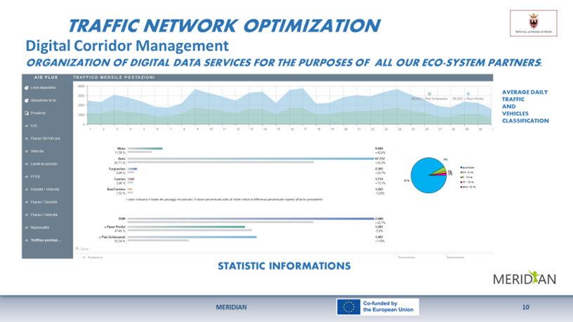
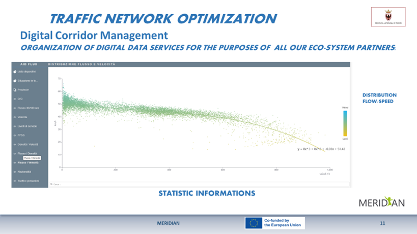
We built a software that uses all the most important algorithms taken from Highway Capacity Manual, arriving to achieve the Level of Service of the most important arcs of the country, managing data either to achieve real time information, or to obtain statistic data.

So, for each core road we have:

Trave time, Flow, Density, Peek hour traffic, average speed, LOS, about global flow but also particular classes of traffic as:

Commuter traffic,
Freight traffic,
Touristic traffic,
Motorbike traffic
……

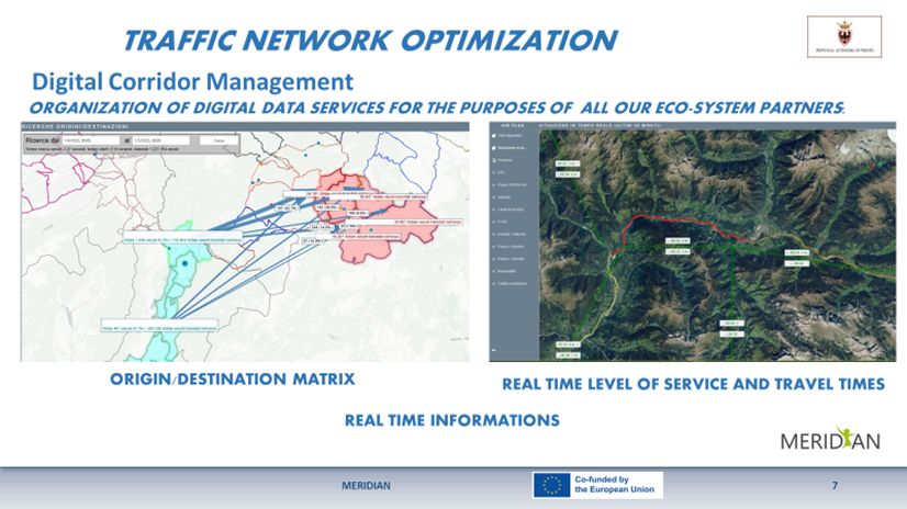
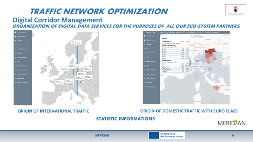
And so, we can fill moment by moment, our accurate origin/destination matrix.

USER INTERFACE
We build a “user system interface” to permit to our system partners to read, use and manage data obtained by software processing.

A part of data will consist in images and screenshots downloadable from system server; another part of data will consist in alphanumeric strings that can be managed and processed by our partner-users

Introduction

This project happens because there is the will to update and modernize the Trentino traffic monitoring network and to make it functional to the changed needs of the Provincia Autonoma di Trento.

The existing network uses only loops and doesn’t permit to obtain O/D matrixes in real time.

This project increases this monitoring network and build the “core information system”. This system in the future could be improved using only smart cameras, because the basis for the right and accurate classification is already done.

Further reading

If readers want to have further information, they can contact: PROVINCIA AUTONOMA DI TRENTO UMSE di Supporto alle attività di manutenzione e gestione stradale Via Gazzoletti, 33 – 38122 Trento mail address: g.anderle@provincia.tn.it

Pictures/media/video's/news items

The core message

Expected results concern two different chapters:

  1. Results expected by our action
  2. Results expected by the action of our partners.


Our Department, with this project, is applying to become the information traffic provider, for all the institutional partners of P.A.T (Provincia Autonoma di Trento).

Furthermore, for the increase of the “sensor network”, we expect that all the new smart cameras bought in Trentino by any public enduser (expecially municipalities) will have to be entered in this digital data system.

So, since all the acquired data will be managed by this software, linking plates with vehicle classification, the result of this kind of working progress, will be a continuous improvement of traffic system analysis.


Anyway, we wait the best results by the action of our institutional partners, that receive and uses our data. We wait:

  • a provision of real time traffic information, reduction of traffic congestion and of car accidents (by the action of Viaggiare In Trentino);
  • a better turism management (by the action of Trentino Marketing);
  • definitions of new restricted traffic zones with a new organization for urban traffic network and definitions of new pedestrian and cycle routes (by the action of Municipalities);
  • a better scheduling of maintenance and adjustment works in the traffic network (by the action of PAT Maintenance Department;
  • the opportunity to introducing the concept of dynamic speed in the main traffic routes (multilanes roads) linked to LOS conditions (speed reduction for safety) (by the action of PAT Infrastructures Department);
  • a better traffic organization for the Brenner corridor, in relation with LOS of A22 highway (By the action of A 22 Highway);
  • a better organization of public bus transport in Trentino area (by the action of Trentino Trasporti);
  • the start of a noise analysis set, for the definition of a SEL Data Base(single event level), useful for a new noise model construction, based upon traffic flow (by the action of PAT Environment Department);