
Here you can find the description of the various Meridian projects
In the field of digitalisation of roads, the importance of Building Information Modelling / Management (BIM) can’t be underestimated. The BIM program of the Flemish Agency for Roads and Traffic aims to provide an answer to the digital collaboration in the infrastructure construction sector.
As a road manager, AWV is applying BIM for collaboration during the design and implementation of projects, and aims for the use of smart information models during further maintenance and operation. Better coordination of roadworks during the infrastructure life cycle will improve efficiency, safety and reduce customer journey disruption and environmental side effects.
BIM is a cornerstone in building a digital twin of our physical road infrastructure on the Core and Comprehensive TEN-T network. It will allow us to shift up a gear towards Cooperative Intelligent Transport Systems (C-ITS) and Cooperative and Connected Automated Mobility (CCAM).
Road digitalization ensures more efficient and therefore cheaper construction sites, but can also save a lot of money in the long term through more efficient maintenance. It is also a necessary source of information to be able to offer road users and input for C-ITS services.
The BIM program is a step to inventorying and digitising infrastructure, in order to obtain a digital twin of the physical infrastructure for data-driven asset management, and which will allow us to support CCAM applications. In this way we are building a safe, smooth and sustainable mobility of tomorrow.
The Building Information Management (BIM) project is a collaborative approach to construction project management that focuses on the creation, sharing, and use of digital models of buildings and infrastructure across the entire life cycle of the infrastructure assets.
Name of the organisation carrying out the project: Flemish government – Agency for Roads and Traffic.
The Steering Committee is formed by representatives from all MERIDIAN partners stated in the Grant Agreement. All beneficiaries and Affiliated Entities are committed to participate.
The MERIDIAN Steering Committee is the steering body of the project, in which decisions are made and technical harmonization is validated. Furthermore, the Steering Committee is the meeting to share knowledge between partners, present task results and discuss on relevant topics. The Steering Committee meets four times a year in one of the participation countries.
Objectives
The primary objective of the BIM project is to improve the efficiency and effectiveness of the entire construction process, from design to maintenance, by leveraging advanced technology and interdisciplinary teamwork.
As such, BIM is a cornerstone in building a digital twin of our physical road infrastructure.
Results expected
One of the key expected results of the BIM project is enhanced collaboration among the various stakeholders involved in the construction process. By sharing a single source of accurate and up-to-date information, architects, engineers, contractors and project managers can work together more effectively to avoid errors, reduce waste, and ensure that the project is completed on time and within budget.
Another expected result is efficiently collecting the available information across the entire life cycle of the infrastructure assets. By gathering that information once, as close to the source as possible, and exchanging it in a standardised way, we can make that uniform data available to those who need it at any time during the life cycle.
Project description
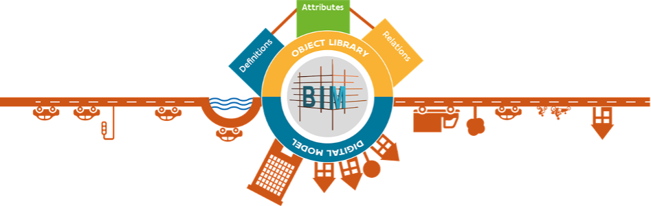
The task entailed the creation of the object type library (OTL) which is a semantic data standard (the same “language”): a description of the information needs for all physical assets. It maps out which objects can be built in Flanders, which definition they have, the properties and relationships in line with the standardisation bodies that describe the building regulations for the infrastructure in Flanders.
The DAVIE portal for contractors was officially launched. DAVIE is an application for Data Acceptance, Validation and Information Extraction. The data portal DAVIE ensures proper reception of the data and flow, conversion to a readable representation of the data in a digital twin database and application, which enables further data management and updates. We offer application users the opportunity to upload data, have it validated automatically against the OTL data standard, then have the content verified and flow to the digital twin database and application.
The OTL Subset Tool (OST) is available for creating custom subsets for a project. The tool allows to specify and define which OTL-compliant BIM data must be supplied to suit a project. The tool helps the road authority and contractors to define the information delivery specification specifically tailored to their project. Webinars explaining the operation and tools and helping contractors use them were organised.
Implementation schedule
The Building Information Management task within the Meridian project was completed at the end of 2022.
The provision of truck parking at rest areas on motorways has not been able to keep pace with the development of heavy traffic in recent years. The current deficit of approx. 12,000 truck parking spaces, according to federal evaluations, confronts the Autobahn GmbH with a task that cannot be covered in the medium term with conventional expansion and new construction measures alone. In this context, telematic parking procedures, truck parking guidance systems and precise information for truck drivers are becoming significantly more important in order to be able to react to the increased demand in the short to medium term.
General background: why is this project happening?
A detection of the occupancy of the truck parking lots is required that is as precise and autonomous as possible. Autobahn GmbH is therefore pursuing the strategy of swift, needs-based equipping of rest areas along the most important routes that are heavily used by heavy traffic.
There are currently around 1,900 rest areas on German motorways – this includes rest areas with and without service facilities – with up to over 300 truck parking spaces per rest area.
Objectives, Results expected, Project description
The first implementation phase included in MERIDIAN focused on on-site monitoring by means of rotating lasers. However, after examining and assessing the different technical approaches to implementing the monitoring system for truck parking spaces at roadside rest areas, the Federal Ministry has identified the toll data-based system as the preferred option. Using this tracking of occupancy based on toll data is equally reliable due to quality and reliability of the available toll data. Moreover, the investment and operating costs of this data-based solution are significantly lower than for any solution requiring physical infrastructure at roadside rest areas, further benefitting the ecologically sustainable aspects of implementations avoiding the need for deployment and cost-intensive operation of technical infrastructure. By avoiding the construction of technical infrastructure, CO2 emission is reduced and the EU Green Deal is supported. The further implementation will be done by the Federal Logistics and Mobility Office (BALM) and using the toll data-based system will provide the same information to facilitate a reduction of parking search traffic caused by trucks as initially planned. The occupancy data on truck parking spaces at roadside rest areas will be also provided publicly via the Federal ‘Mobilithek’ platform, the German National Access Point (NAP).
The Steering Committee is formed by representatives from all MERIDIAN partners stated in the Grant Agreement. All beneficiaries and Affiliated Entities are committed to participate.
The MERIDIAN Steering Committee is the steering body of the project, in which decisions are made and technical harmonization is validated. Furthermore, the Steering Committee is the meeting to share knowledge between partners, present task results and discuss on relevant topics. The Steering Committee meets four times a year in one of the participation countries.
Provision of truck parking information on the most important rest areas along the European long-distance freight corridors in Germany
Anas (FS Italiane Group), the major Italian road operator, has launched the Smart (Safe, Multimedial, Accessible, Renewable and Technological) Road project (as a part of Smart Mobility Program) with the aim of leading Italy towards the digital transformation of its road infrastructure. The objective is to realize an efficient road network in order to improve and create services that enhance mobility and monitories roads.
The services to be implemented as part of in the overall Smart Mobility Program will improve:
One of the most important itineraries covered by the Program is the A19 – Palermo Catania highway that is part of on the TEN-T Scandinavian-Mediterranean Core Network Corridor and connects Sicilian cities of Palermo and Catania.
Along this highway, to implement mentioned services, Anas is installing cameras for image processing, radiocommunication devices, traffic detectors as well as the implementation of wireless connectivity and traffic/road management software systems.
Anas Smart Mobility Program is a plan of road development through different itineraries in the Northern, Central and Southern part of Italian country, conceived to bolsters road management by providing powerful monitoring and control tools and enhance road users’ driving experience by a set of C-ITS (Cooperative-Intelligent Transport Systems).
According to European development and digitalization process of infrastructures, by the implementation of C-ITS Services has the aim to attain primarily the following targets:
In order to fulfil increasingly demanding traffic management and safety requirements Anas S.p.A., in the field of Anas Smart Mobility Program, has been turning the A19 Palermo Catania highway into a “Smart Road“: an ecosystem of ground-breaking technologies designed to advocate a new mobility model, aimed at promoting communication and sustainability as well as paving the way for autonomous driving.
The Steering Committee is formed by representatives from all MERIDIAN partners stated in the Grant Agreement. All beneficiaries and Affiliated Entities are committed to participate.
The MERIDIAN Steering Committee is the steering body of the project, in which decisions are made and technical harmonization is validated. Furthermore, the Steering Committee is the meeting to share knowledge between partners, present task results and discuss on relevant topics. The Steering Committee meets four times a year in one of the participation countries.
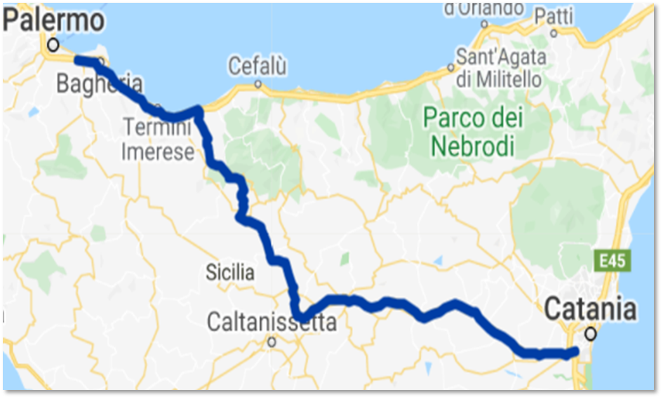
A19 – Palermo Catania highway has been playing a crucial role in connecting people in Sicily since 1975. The highway connects Sicilian cities of Palermo and Catania by crossing central Sicily and passing through Caltanissetta and Enna with an overall length of about 191 km.
The activity planned for this highway is dedicated to the deployment and configuration of first ~30 kilometers near Palermo of smart technologies.
The project includes the installation of cameras for image processing, radiocommunication devices, traffic detectors as well as the implementation of wireless connectivity and software systems The project will improve road safety and traffic efficiency through infrastructure-to vehicle C-ITS technologies. Completion of the project, firstly planned for the end of 2023, is currently scheduled for the end of 2024.
The goal of this project is to improve the safety and reliability of the TEN-T network in general with the implementation of the harmonized traffic counting points system in the whole comprehensive and core network of the TEN-T in Latvia which will allow more effective and safe management of traffic.
This project will help to achieve the modernization of the transport infrastructure for the core and comprehensive networks of the TEN-T. In Latvia, modern technological solutions will be implemented for existing and new traffic counting points, based on the result of the study. Counting points will also be installed on illuminated pedestrian/bicycle paths near the TEN-T network to determine pedestrian presence during night-time and control the illumination accordingly. To collect, analyze and manage all traffic data that will be available from the new ITS infrastructure, a modernized traffic management program will be implemented. In the TEN-T network in Latvia there will therefore be ITS solutions and possibilities to manage traffic equal to other EU countries.
To ensure the digitalization of transport sectors and increase the availability of data for transport safety in the whole TEN-T road network, it is important to involve smart and innovative solutions for the creation, collection, management, sharing, and dissemination of transport data. In Latvia, this is still an unsolved but essential issue. Especially related to the implementation of transport National Access Point (NAP). Therefore, on the core and comprehensive networks of the TEN-T in the territory of Latvia this project is planned to introduce digital solutions for the creation and management of traffic data.
Realization of this project will supplement project No.6.1.6.0/21/I/001 implemented by LSR (2021-2023) and co-financed by the Cohesion Fund “Implementation of the national access point for transport sector information in Latvia” (NAP project) and promote compliance with the requirements of the ITS Directive and Regulations No. 885/2013, No. 886/2013, No. 2015/96, No. 2017/1926. Due to the implementation of this project, the missing part of the NAP project, which is urgently important for the functioning of the NAP, will be implemented – the creation and management of the traffic data.
The Steering Committee is formed by representatives from all MERIDIAN partners stated in the Grant Agreement. All beneficiaries and Affiliated Entities are committed to participate.
The MERIDIAN Steering Committee is the steering body of the project, in which decisions are made and technical harmonization is validated. Furthermore, the Steering Committee is the meeting to share knowledge between partners, present task results and discuss on relevant topics. The Steering Committee meets four times a year in one of the participation countries.
The main objective of this project is to improve the safety and reliability of the TEN-T network in Latvia.
Four main activities will be implemented till the end of the MERIDIAN project in December 2025:
The main task of the study is to evaluate the efficiency of the existing traffic counting point layout in the TEN-T network in Latvia and to provide recommendations for the improvement and expansion of the traffic counting network, locations, and remote sensor type of traffic counting points. This study will be used to modernize at least 37 existing permanent traffic counting points by replacing induction loop sensors with radar or laser-type sensors. The main benefit is moving all traffic counting equipment out of the carriageway, so there is no need to renew the sensors when repaving the section or in the case when the magnetic loops are damaged due to pavement deformations, thus reducing maintenance costs.
It is planned to modernize existing permanent traffic counting points with non-invasive sensors. And improve the TEN-T network coverage in Latvia with approximately 20 new permanent traffic counting points by installing the same equipment as in previously modernized traffic counting points. This is necessary because they will ensure the acquisition and data transfer in DATEX II format so that it will be possible to integrate this information with NAP services. The following data will be obtained: traffic intensity (number), movement speed, classification, and direction.
Vulnerable road users are not currently counted. The obtained data will be used to control the lighting intensity. By analyzing the trends and intensity of movement, it will be possible to determine the time frame when the lighting level could be reduced to a minimum or switched off, thus achieving energy savings, and maintaining safety.
Improved traffic data analysis provides analysis of traffic processes, which is essential for understanding road network performance. A wide range of analytics can help users monitor travel time, build traffic patterns, and monitor congestion. Traffic engineers can prepare reports and act where needed.
This project will improve the safety and reliability of the TEN-T network in general with the implementation of the harmonized traffic counting points system in the whole comprehensive and core network of the TEN-T in Latvia which will allow more effective and safe management of traffic.
The main objective of this project is to optimize the use of existing road infrastructure capacity.
It will help to achieve the modernization and digitalization of the transport infrastructure for the core and comprehensive networks of the TEN-T by implementing digitalized data about transport infrastructure in Latvia. Digitalized data will include detailed information about location, condition, technical parameters, and other important information about assets on the TEN-T core and comprehensive network in Latvia. That will be achieved by using modern digital equipment and solutions (laser scanning technologies, artificial intelligence). These data will be harmonized with National Access Point and LST asset management systems and used for the improvement of the traffic and road maintenance management work. Improvement of transport data availability will ensure more optimal and effective usage of financial resources, planning of maintenance works, and management.
To ensure the digitalization of transport sectors and increase the availability of data for transport safety in the whole TEN-T road network, it is important to involve smart and innovative solutions for the creation, collection, management, sharing, and dissemination of transport data. In Latvia, this is still an unsolved but essential issue. Especially related to the implementation of transport National Access Point (NAP). Therefore, on the core and comprehensive networks of the TEN-T in the territory of Latvia in this project is planned to introduce innovative digital solutions for the creation and management of the transport assets data by using non-intrusive and non-destructive measurement technology and artificial intelligence.
During this project, an improved asset management system and technical solutions for the data collection on the TEN-T network in Latvia would serve as a basis for interconnection with other information systems and provide these systems with up-to-date data on the national road network. The data and information stored in the LSR’s asset management system will be transferred to the NAP for road transport sector information and other open data portals, following the data structure set out in the INSPIRE Directive.
Realization of this project will supplement project No.6.1.6.0/21/I/001 implemented by LSR (2021-2023) and co-financed by the Cohesion Fund “Implementation of the national access point for transport sector information in Latvia” (NAP project) and promote compliance with the requirements of the ITS Directive and Regulations No. 885/2013, No. 886/2013, No. 2015/96, No. 2017/1926. Due to the implementation of this project, the missing part of the NAP project, which is urgently important for the functioning of the NAP, will be implemented – the creation and management of the transport asset data. This project will also promote the implementation of the INSPIRE Directive (No. 2007/2 / EC), ensuring the collection and transfer of digital data about public transport infrastructure to national and EU-level geoportals.
The Steering Committee is formed by representatives from all MERIDIAN partners stated in the Grant Agreement. All beneficiaries and Affiliated Entities are committed to participate.
The MERIDIAN Steering Committee is the steering body of the project, in which decisions are made and technical harmonization is validated. Furthermore, the Steering Committee is the meeting to share knowledge between partners, present task results and discuss on relevant topics. The Steering Committee meets four times a year in one of the participation countries.
The main objective of this project is to optimize the use of existing road infrastructure capacity.
Two main activities will be implemented till the end of the MERIDIAN project in December 2025:
With a regular survey of the road network with dedicated measurement equipment will be collected the most up-to-date data on the structural (bearing capacity) and functional (roughness, different damage) properties of the road pavement, and the condition of its assets (markings, road signs). That will provide an opportunity to analyze current and historical information about the infrastructure. To provide the asset management system with the most up-to-date information on the condition of the assets, it is necessary to provide LSR employees with suitable equipment for fieldwork and information recording. Such equipment will facilitate the work and provide opportunities for more efficient exchange and input of information into the systems away from the office. Analysis and comparison of the obtained data in the system using computer vision and artificial intelligence will be done. Development of customized software solutions for historical, and current transport infrastructure data collection, analysis, and modeling of causal relations. The obtained information will be used for predictive road maintenance and planning of renovation works.
Creation of high-performance data infrastructure. That is necessary to ensure the continuous operation of the system (server) with several simultaneous connections. High-capacity cloud-based infrastructure under the direct management of LVC will ensure uninterrupted availability and operation of the system.
The main benefit of this project will be increased effectiveness of road asset operation and management, and the availability of data for decision-making support in relevant business processes of transport safety, collaborative logistics, and multimodal travel.
The primary users of the project results will be the LSR structural departments and the owner of the state road infrastructure – the Ministry of Transport of the Republic of Latvia. Named parties will benefit by using modern technology to collect, disseminate, and use the transport infrastructure data for the needs of the national access point, TEN-T network road maintenance, and reconstruction in Latvia. In turn, the secondary users of the project results will be the whole society – users of the TEN-T network. When more accurate and up-to-date data about road infrastructure is available for society, safer and faster traffic will be ensured. In addition, from the implementation of this project, increased efficiency of the national and EU funds used for the reconstruction and maintenance of the road infrastructure will be achieved. For example, by knowing the traffic intensity and adding advanced data on the pavement condition, a more accurate list of priority of road sections that need to be reconstructed can be developed. In this way, the available funds can be invested directly in those road infrastructure projects where it is most necessary from the societal, safety, and road infrastructure sustainability point of view.
Within the project ‘Digitalisering Overheden’ (=Data Driven Government) a dashboard framework was developed to show quality indicators for several datastreams for which NDW (National Data Warehouse) has the responsibility to deliver the information.
Also a number of quality indicators has been developed and are now updated every month. This is done for dynamic maximum speeds (MSI), bridge openings, parking information, intelligent traffic lights (iVRI), logistics (environmental zones, safety zones, ..) and bicycle counts. All this information is made accessible to all the road authority institutions in the Netherlands.
The information is used by the road authorities to increase the data quality of the distributed data, so that it can be safely used in car to assist the driver. The data is also used to assess whether the data quality is good enough to be used for policy making and monitoring.
There was a strong demand from the service providers to have reliable and high quality data on the data elements mentioned above. This request resulted in a country-wide approach where data quality is realised through regional data teams and dashboards using critical performance indicators which report the state of data top 15 items.
The Steering Committee is formed by representatives from all MERIDIAN partners stated in the Grant Agreement. All beneficiaries and Affiliated Entities are committed to participate.
The MERIDIAN Steering Committee is the steering body of the project, in which decisions are made and technical harmonization is validated. Furthermore, the Steering Committee is the meeting to share knowledge between partners, present task results and discuss on relevant topics. The Steering Committee meets four times a year in one of the participation countries.
Objective:
To realize a dashboard on top of a chain of links in order to guarantee data quality for prioritized data in NL (planned roadworks, incidents, maximum speeds, road signs, VMS signs, bridge openings, static and dynamic parking data, event data, intelligent traffic light data, logistic data, cycling data.) The data items are important and complex to generate.
Expected results:
The dashboard is the managing level for the Regional Data Teams and consists of critical performance indicators and drill down options, explaining possibles causes for unsufficient performance.
Implementation schedule:
2021-2022
The Data Turbo Pipeline (DTP) is a program that improves the incident management proces by using data driven technologies and artificial intelligence. Pre-evaluation reported that by using these technologies, we can reduce the number standard messages mainly phone calls) between Traffic managers and road inspector by 400.000 (out of approximately 1.000.000 calls). DTP is an ongoing process in which new tools are developed to make the process of incident management faster and more efficient. In the first batch of developments we have got the following items:
– Digital assigning of road inspectors; with a click on the button a traffic manager can assign a road inspector to an incident, instead of calling by phone.
– Digital connexion with towing companies; with a click on the button a traffic manager can assign a towing company, instead of calling the call centres (in many cases minutes wait).
– Algorithm for optimal spreading of road inspectors over the core network; The algorithm decides an optimal position of the road inspector which results in a higher percentage of incidents that can be reached within 15 minutes.
– Digital message of arriving road inspector at an incident; in the past road inspectors called the traffic centre after arrival at an incident. This time can better be spend on first traffic guidance and help. With this development the traffic centre gets an automatic message of arrival when a road inspector has arrived at an incident location.
– Connexion with service providers for increase in speed of starting Incident management.
By using Artificial intelligence Rijkswaterstaat can reduce the travel time of road inspectors, which increases safety and reduces congestion.
Artificial intelligence can tell the road inspectors what the best place on our core network is, or which direction they have to drive in order to get an optimal distribution over the core network.
An algorithm determines this using:
The Steering Committee is formed by representatives from all MERIDIAN partners stated in the Grant Agreement. All beneficiaries and Affiliated Entities are committed to participate.
The MERIDIAN Steering Committee is the steering body of the project, in which decisions are made and technical harmonization is validated. Furthermore, the Steering Committee is the meeting to share knowledge between partners, present task results and discuss on relevant topics. The Steering Committee meets four times a year in one of the participation countries.
Objective:
reduce travel time of road inspectors, which means increase of safety and reduce of congestion.
Expected results:
Due to the implementation of these technologies and use of AI, travel time of road inspectors will approximately decrease by 15% (4 minutes on average), which means that incidents are secured by road inspectors for a longer period. Also the digital connection with towing companies reduces time needed for clearing the road makes the work of traffic centres more efficient.
Implementation schedule:
2021-2024
Providing free-flowing, safe ways of getting around is an important priority for the Flemish government. To enable us to reach that goal, we have put an ambitious program in place in Flanders. Called Mobilidata, the program has set itself some ambitious goals:
To achieve these aims, Mobilidata is busy putting in place a network of smart, sustainable and reliable data sources. But how do we get this smart data to you, as a road-user? That’s something you take care of yourself! It works like this: your smartphone sends out a cellular signal, which enables ‘communication’ to be established with our connected systems. Mobilidata’s smart infrastructure then tracks that signal and combines it with other real-time data. This in turn makes it possible, for example, for traffic lights to take your mobility needs into consideration better. Over time, a smart data infrastructure of this kind will provide the basis for the road infrastructure that will enable driverless vehicles in Flanders.
The Mobilidata program is co-creating a whole raft of innovative mobility solutions with private partners, based on a digital infrastructure, smart traffic lights and high-quality, sustainable data sources. By working with Mobilidata solutions, policymakers, businesses, government departments, local residents and app-builders can all combine to make being on the road smoother, more sustainable, more comfortable and safer for every road-user.
The mission of Mobilidata is to create innovative traffic solutions to make traffic safer, more efficient and sustainable for all road users. This, by implementing a sustainable digital data-infrastructure and intelligent traffic light controllers and by stimulating the use of innovative traffic applications in line with Flemish mobility policy.
Name of the organisation carrying out the project: Flemish government – Agency for Roads and Traffic
The Steering Committee is formed by representatives from all MERIDIAN partners stated in the Grant Agreement. All beneficiaries and Affiliated Entities are committed to participate.
The MERIDIAN Steering Committee is the steering body of the project, in which decisions are made and technical harmonization is validated. Furthermore, the Steering Committee is the meeting to share knowledge between partners, present task results and discuss on relevant topics. The Steering Committee meets four times a year in one of the participation countries.
Objectives
The objective is to increase road safety by servicing road users with reliable traffic info; to make cities more liveable by improving the air quality and stimulating a modal shift.
Results expected
The expected results of the Mobilidata program is to use innovative traffic solutions to make traffic safer, more efficient, and sustainable for all road users.
Project description
In the Mobilidata task in the Meridian project aims to roll-out at the one hand side hundreds of intelligent Traffic Light Controllers (iTLCs), and on the other hand the deployment of the core platform.
The cooperative Intelligent Transport System (C-ITS) is based on cellular communications and will implement 30 use cases (UCs) covering day 1 and day 1.5 services.
Implementation schedule:
The Mobilidata task in Meridian started early 2021 and will last until the end of 2024. From spring 2023 onwards several use cases will be gradually implemented.
C-ITS systems stand for safe and intelligent mobility, which is achieved by networking vehicles and infrastructure.
Traffic obstacles such as roadworks sites can be noticed more quickly, and dangers can be reduced. This is achieved through so-called Car2X communication, i.e., the direct exchange of anonymized information between vehicles, roadside infrastructure, and traffic control centers.
The first cooperative service went live in mid-2021. A “roadworks warning” system communicates with a mass production vehicle (currently the new Golf 8, ID-3 and ID-4 from VW) on the motorways in the Rhine-Main area. As soon as this type of vehicle approaches short-term roadworks, the driver is informed about it before it comes into view and can adapt his driving behavior accordingly.
The official Roll-out of road works warning (RWW) system has taken place in October 2022 (see Video)
General background: why is this project happening?
Reduction of risk of accidents with associated significant personal injury and provision of national wide, georeferenced real time road works information at the NAP.
The C-ITS roll-out is a flagship project of Autobahn GmbH and is therefore the focus of the CEO.
The Steering Committee is formed by representatives from all MERIDIAN partners stated in the Grant Agreement. All beneficiaries and Affiliated Entities are committed to participate.
The MERIDIAN Steering Committee is the steering body of the project, in which decisions are made and technical harmonization is validated. Furthermore, the Steering Committee is the meeting to share knowledge between partners, present task results and discuss on relevant topics. The Steering Committee meets four times a year in one of the participation countries.
Objectives, Results expected, Project description, Implementation schedule
From 2022-2024 a massive roll-out of this technique on all strategic corridors Germany-wide will be performed by all 10 branch offices of Autobahn GmbH. While the retrofitting of the existing technical equipment, which will take place in 2022, will be co-funded as part of the EU funding project UMneo (Phase I), MERIDIAN only includes Phase II: procurement of up to 3000 roadside units. MERIDIAN tasks also include the implementation of the technical equipment for the “C-ITS Central Station in Traffic Centre Germany”, which will be integrated into Autobahn’s “platform strategy” of Traffic Centers
Port Authority Network of the North Tyrrhenian Sea (AdSP MTS) is the public body, established with Law no.169/2016, that manages and coordinates the seaports of Livorno (Core network), Piombino and Portoferraio (Comprehensive network), along with minor ports located in the Tuscan Archipelago.
It has therefore direct competence on those seaports, including access routes and rail connections to the national and European networks, along with sustaining and developing port operations in accordance with Italian and EU policies. AdSP MTS has set up an Innovation Agenda, in the time horizon 2021-2026, for investing in innovative and cutting-edge technologies applied to the port and logistic domain.
AdSP MTS is in charge of planning and developing sustainably port activities and therefore has direct competences not only in medium and large infrastructural development projects, including energy production, but also in ensuring that private operators abide by port and national rules in their activities.
Hence, it has developed a long-standing experience in managing port community, implementing interventions in worth of over 25 million euros. In last years, the focus has been much more oriented to renewable energies and green energy, with a strong attention to wind, solar, as well as to hydrogen as a carrier.
The Port Authority Network of the North Tyrrhenian Sea does not perform economic activities on the market.
The Steering Committee is formed by representatives from all MERIDIAN partners stated in the Grant Agreement. All beneficiaries and Affiliated Entities are committed to participate.
The MERIDIAN Steering Committee is the steering body of the project, in which decisions are made and technical harmonization is validated. Furthermore, the Steering Committee is the meeting to share knowledge between partners, present task results and discuss on relevant topics. The Steering Committee meets four times a year in one of the participation countries.
Port Authority Network of the Northern Tyrrhenian Sea will develop its own C-ITS system conceived within the Ursa Major Neo project with a “day 2” advancement for the connection of the port with the hinterland, also through the integration of different operator platforms within a “federated” approach.
The aim is to go towards various enablers, not only port but also logistics operators (logistics platforms, road drivers, vehicle network managers), ICT providers and standardization bodies to which to add public entities such as port authorities.
The main purpose is to facilitate the management of the traffic that gravitates around the port, both in the entry and exit mode, with the aim of removing bottlenecks, obtaining safety information and a platform for smart truck parking (both for the management of parking stalls and for booking options)
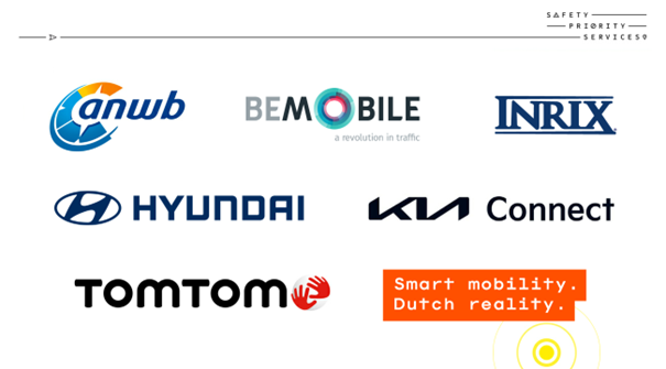
Safety Priority Services is a partnership with ANWB, Be-Mobile (with Flitsmeister), KIA, Hyundai, INRIX and TomTom (2022-2024). The partnership is based on roll out of Safety related traffic services: Jam Tail Warning, Emergency Vehicles Approaching, SRTI and Traffic Laws. Partners are also encouraged to give Feedback on the public data feeds and give User insights based on the experiences perceived by the end user of the services.
Delivery of services, user insights and feedback loop
All services in scope are provided by one or more Partners, as are the feedback loop and the user insights. The current coverage (2022) of the services with a variable (km-based) remuneration is approximately 24 million vehicle kilometers. This is about 35% more than anticipated at the start of this initiative. An additional increase in the number of vehicle kilometers can be expected when more services are delivered by more service providers.
In addition, the rise in crowd-sourced and probe vehicle data will increase the number of SRTI events.
This year (2023) will be all about further roll-out and quality improvement.
Feedback
An important part of this collaboration is improving the public data. The Partners were asked to assess the data on various quality aspects. The nature and form of the feedback varies greatly per Partner. This is partly due to the Partner’s experience and familiarity with the open data feeds that NDW provides. In 2022, we purposely left this open to allow the Partners, to a certain degree, to freely interpret the delivery of the feedback. Ultimately, we want to work towards a more uniform and automated feedback delivery.
User insights
Preliminary user insights show that road users adjust their speed and drive more alertly after having received a warning about, for example, a broken-down vehicle ahead. Received warnings such as traffic jam warnings or warnings of approaching emergency vehicles are highly appreciated. The results will be processed in the National Smart Mobility monitor. Here are a few things we learned after the first year of Safety Priority Services:
Approaching” message made way. Another 46% were more alert.
The Steering Committee is formed by representatives from all MERIDIAN partners stated in the Grant Agreement. All beneficiaries and Affiliated Entities are committed to participate.
The MERIDIAN Steering Committee is the steering body of the project, in which decisions are made and technical harmonization is validated. Furthermore, the Steering Committee is the meeting to share knowledge between partners, present task results and discuss on relevant topics. The Steering Committee meets four times a year in one of the participation countries.
Safety Priority Services makes it possible to inform and warn road users on all roads in the Netherlands, including on the often relatively unsafe provincial and local roads. This collaboration between government and companies also provides more insight into the impact of these traffic warnings and the quality and usability of the available (government) data. This offers the opportunity to improve it where necessary.
The Flemish motorway network is one of the densest and most congested networks in Europe. In order to solve the congestion problems many actions are taken. New infrastructure is being built (e.g. the extension of the motorway ring of Antwerp) and there are many incentives to stimulate the use of other modes of transport, both for passenger transport as well as for freight transport.
A specific measure to counter congestion is to create peak hour lanes on sections nearby cities, by opening the hard shoulder lane for road traffic during rush hours.
In the Meridian project there are 3 peak hour lane implementations. There will be peak hour lanes and variable speed limits and supporting Intelligent Transport System (ITS) infrastructure on the E40 highway between Ternat and Affligem in the direction of Ghent.
A second implementation encompasses variable speed limits and supporting ITS infrastructure on the E40 highway between Bertem and Sterrebeek in the direction of Brussels. The third implementation deals with the deployment of variable speed limits and supporting ITS infrastructure on the E17 in the region of Kortrijk in the direction of France.
Studies have indicated that there are a lot of congestions on the E40 highway between Ternat and Affligem, the E40 highway between Bertem and Sterrebeek and on the E17 in the region of Kortrijk. This results in time loss and incidents. These projects aim to make the Flemish highways safer for all road users.
Name of the organisation carrying out the project: Flemish government – Agency for Roads and Traffic.
The Steering Committee is formed by representatives from all MERIDIAN partners stated in the Grant Agreement. All beneficiaries and Affiliated Entities are committed to participate.
The MERIDIAN Steering Committee is the steering body of the project, in which decisions are made and technical harmonization is validated. Furthermore, the Steering Committee is the meeting to share knowledge between partners, present task results and discuss on relevant topics. The Steering Committee meets four times a year in one of the participation countries.
The Steering Committee is formed by representatives from all MERIDIAN partners stated in the Grant Agreement. All beneficiaries and Affiliated Entities are committed to participate.
The MERIDIAN Steering Committee is the steering body of the project, in which decisions are made and technical harmonization is validated. Furthermore, the Steering Committee is the meeting to share knowledge between partners, present task results and discuss on relevant topics. The Steering Committee meets four times a year in one of the participation countries.
Objectives:
The objective of a peak hour lane is to reduce congestion and to better utilise the existing infrastructure. But there is also a risk. By reducing travel time on the motorway, the incentive to use another transport mode or another time frame is disappearing. It could mean that more users change from public transport to the car, the inverse of the modal shift that one wants to achieve. To avoid this, the Flemish ministry in general only implements peak hour lanes for traffic that leaves the city (outbound traffic). The idea behind it is that the car users are still confronted with traffic jams in the morning when they enter the city. So, there is still a stimulus to use another transport mode. Thanks to the peak hour lane the traffic is leaving the city more easily, resulting in less traffic jams in the city.
Results expected:
The goal of this project is creating additional capacity on the E40 and E17 highways during rush hours. The E40 and E17 are important highways for business, freight and leisure traffic. Fluent traffic flow is an economic necessity. By using peak hour lanes, we make optimal use of existing road infrastructure capacity, we improve the safety and reliability of the network. In addition, by avoiding traffic jams on the highway, we avoid cars and heavy good vehicles will search their way through the secondary road network, as such creating traffic jams in smaller communities or introducing heavy traffic near school environments.
Project description:
There are several methods for implementing peak hour lanes. One can use a simple signpost with a VMS to indicate if the peak hour lane is open or not. The Flemish ministry is using gantries with a VMS sign per lane and additional VMS between the lanes. It means that not only the function peak hour lane is implemented but also dynamic lane control, speed limit, incident warning and dynamic overtake ban.
The systems are integrated in the Flemish Traffic Management Centre, and the data are fed into the lane signalling and the dynamic information board messages (VMS) open data feeds. As such the lane signalling can be integrated into navigation systems or in-car signage.
Implementation schedule:
E17 in the region of Kortrijk in the direction of France: will be implemented in the summer of 2023.
E40 between Ternat and Affligem: will be implemented in the fall of 2023.
E40 between Bertem and Sterrebeek in the direction of Brussels: will be implemented end 2023 – beginning 2024.
This task within the Meridian project is composed of 3 sub-tasks on 3 of the tunnels located on the Core and Comprehensive TEN-T road network, i.e. the Kennedy tunnel, the Tijsmans tunnel and the Craeybeckx tunnel:
The Agency for Roads and Traffic is constantly improving the safety of the tunnels and particularly of the tunnels on the TEN-T road network.
To reach his goal different techniques are implemented during the maintenance windows or planned refurbishing windows. Different traffic management techniques, such as cameras, automatic incident detection, dynamic signalization, tunnel closure systems and public address speakers have different goals, but they all aim to increase safety for the road user and for emergency services.
Name of the organisation carrying out the project: Flemish government – Agency for Roads and Traffic.
The Steering Committee is formed by representatives from all MERIDIAN partners stated in the Grant Agreement. All beneficiaries and Affiliated Entities are committed to participate.
The MERIDIAN Steering Committee is the steering body of the project, in which decisions are made and technical harmonization is validated. Furthermore, the Steering Committee is the meeting to share knowledge between partners, present task results and discuss on relevant topics. The Steering Committee meets four times a year in one of the participation countries.
The Steering Committee is formed by representatives from all MERIDIAN partners stated in the Grant Agreement. All beneficiaries and Affiliated Entities are committed to participate.
The MERIDIAN Steering Committee is the steering body of the project, in which decisions are made and technical harmonization is validated. Furthermore, the Steering Committee is the meeting to share knowledge between partners, present task results and discuss on relevant topics. The Steering Committee meets four times a year in one of the participation countries.
Objectives:
The objective of these incremental measures is to increase the safety in and around 3 of our TERN road tunnels.
Results expected:
The project increases the safety and hence the road network reliability for the road users on the Core TEN-T network. In addition, also the safety for the emergency services during tunnel incidents is improved, and it shortens the time needed to stabilise the event/incident and to clear the road. Improved incident management will lead to faster restoration of the traffic flow.
Project description:
The project implements incremental safety measures for 3 of the Flemish TERN tunnels, of which the Kennedy tunnel is one of the busiest tunnels in Flanders.
Implementation schedule:
Craeybeckx tunnel: completed and in service (2022)
Tijsmans tunnel: completed and in service (2021-2022)
Kennedy tunnel: the tube in the direction of Ghent is completed, while the tube in the direction of the Netherlands is planned to be completed summer 2023.
Autobahn GmbH will develop the German motorways into a completely digital, networked, and automated traffic system, so that use of the road infrastructure can be optimized, and the road users can reach their destination safely and in a more environmentally friendly manner. The focus in MERIDIAN is on traffic corridors on the trans-European axes between the major economic and metropolitan regions in Germany (Picture 2). It is precisely on these that high availability and a reliable, efficient motorway network are of the greatest economic importance, with truck parking lot management and event management in the foreground (Picture 1).
General background: why is this project happening?
Autobahn GmbH will develop the German motorways into a completely digital, networked, and automated traffic system, so that use of the road infrastructure can be optimized, and the road users can reach their destination safely and in a more environmentally friendly manner
The Steering Committee is formed by representatives from all MERIDIAN partners stated in the Grant Agreement. All beneficiaries and Affiliated Entities are committed to participate.
The MERIDIAN Steering Committee is the steering body of the project, in which decisions are made and technical harmonization is validated. Furthermore, the Steering Committee is the meeting to share knowledge between partners, present task results and discuss on relevant topics. The Steering Committee meets four times a year in one of the participation countries.
Objectives, Results expected, Project description, Implementation schedule
Cross-Border TMPs between Germany and its neighboring Member States and digital traffic management of the 7 strategic corridors in Germany
To establish successful corridor management for Germany, the software-technical basis is crucial. Against this background, the corridor management application was initially developed and successfully put into operation in 2021. As a MERIDIAN implementation this software will be expanded accordingly in the next two years to include the various use cases (truck parking lot management, etc.). (Pictures 3,4,5)
The second important building block for the success of the project is a well-organized and effective handling of the project. The project management contract was awarded in 2022.
Further, this task will also cover the participation of Die Autobahn in the Digital Green Brenner Corridor initiative
The roll our of ArbIS to regional partners on the Alpine corridor is essential for traffic management and traffic information provision to drivers on this route. Including information on planned roadworks on secondary roads is core to establish a sound planning structure to avoid traffic jams by rerouting the traffic streams from one to another roadworks in the planning stage while traffic information on current roadworks is essential for routing and ad hoc traffic management services.
The roll our of ArbIS to regional partners on the Alpine corridor is essential for traffic management and traffic information provision to drivers on this route. Including information on planned roadworks on secondary roads is core to establish a sound planning structure to avoid traffic jams by rerouting the traffic streams from one to another roadworks in the planning stage while traffic information on current roadworks is essential for routing and ad hoc traffic management services.
The Steering Committee is formed by representatives from all MERIDIAN partners stated in the Grant Agreement. All beneficiaries and Affiliated Entities are committed to participate.
The MERIDIAN Steering Committee is the steering body of the project, in which decisions are made and technical harmonization is validated. Furthermore, the Steering Committee is the meeting to share knowledge between partners, present task results and discuss on relevant topics. The Steering Committee meets four times a year in one of the participation countries.
The roll out of ArbIS to regional partners on the Alpine corridor significantly enhances will enhance traffic information and traffic management on the alpine corridor. The task follows this implementation schedule:
The aim of the task is to improve traveler information in Bavaria and all neighboring regions by exchanging data from traffic information centers. The data exchanged in this project can also be used for traffic management. The knowledge of the traffic situation can improve the decisions of travellers and traffic managers.
The Steering Committee is formed by representatives from all MERIDIAN partners stated in the Grant Agreement. All beneficiaries and Affiliated Entities are committed to participate.
The MERIDIAN Steering Committee is the steering body of the project, in which decisions are made and technical harmonization is validated. Furthermore, the Steering Committee is the meeting to share knowledge between partners, present task results and discuss on relevant topics. The Steering Committee meets four times a year in one of the participation countries.
The data extension and exchange will enhance traffic information and traffic management on the alpine corridor. The task follows this implementation schedule:
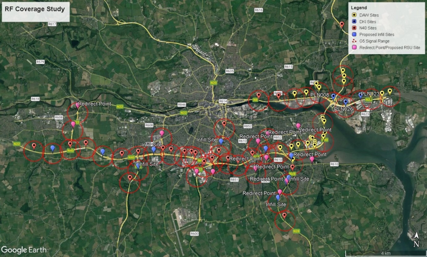
The project involves deploying state-of-the-art Intelligent Transportation System (ITS) and Connected Mobility equipment and infrastructure along the N7/M7 national primary road, covering the sections between junctions 1 and 11. The primary goal of the project is to enhance traffic management and improve overall road safety.
The scope of the project includes the delivery, supply, and installation of the following service level two ITS sub-systems, focused on informing and monitoring traffic.
One of the innovative aspects of the project is the technology trial, which will test the effectiveness of fibre cabling laid down during the deployment. This cabling will be used for automatic incident detection (AID) through the implementation of advanced acoustic sensing technology. This cutting-edge approach promises to revolutionise incident detection and response on the road.
By implementing these ITS solutions, the project aims to achieve several key objectives. First and foremost, it will significantly enhance safety management, reducing the occurrence of accidents (in some cases) and improving incident response times. Additionally, it will lead to increased traffic efficiency and reduced congestion, benefiting both regular commuters and commercial drivers. Furthermore, the project’s emphasis on eco-friendly transport solutions will help minimise environmental impacts associated with road usage.
In conclusion, this innovative project aims to transform the N7/M7 road corridor into a digital corridor and a connected mobility-ready route with improved safety, enhanced traffic flow, and reduced environmental impact, benefitting both road operators and users
Transport Infrastructure Ireland has not only recognised the pressing need for a more efficient traffic management system but is also fully committed to implementing a well-defined roadmap for establishing crucial digital corridors. This initiative aims to address the continuously increasing transportation demand and leverage the latest technological advancements in the sector, emphasising the importance of having a Connected Intelligent Transport Systems (C-ITS) ready infrastructure. By doing so, the project seeks to significantly enhance traffic management efficiency and pave the way for a more connected and sustainable transportation network.
The Steering Committee is formed by representatives from all MERIDIAN partners stated in the Grant Agreement. All beneficiaries and Affiliated Entities are committed to participate.
The MERIDIAN Steering Committee is the steering body of the project, in which decisions are made and technical harmonization is validated. Furthermore, the Steering Committee is the meeting to share knowledge between partners, present task results and discuss on relevant topics. The Steering Committee meets four times a year in one of the participation countries.
Objectives:
A core objective of the Transport Infrastructure Ireland (TII) is to establish a comprehensive digital corridor, integrating a connected Intelligent Transportation System (ITS) ecosystem across the national road network. Aligned with this vision, the project aims to significantly enhance the road management system, introducing the following key improvements:
Results expected:
Considering the above, the project is expected to make a significant contribution to realising a more efficient and digitally advanced road management system. It will not only enhance overall traffic flow and safety on the M7/N7 corridor but also play a vital role in establishing a connected ITS ecosystem throughout the national road network, benefiting commuters and travelers across the region.
Implementation Schedule
2021-2024
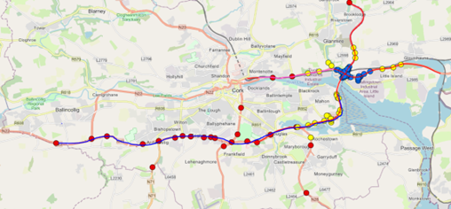
Transport Infrastructure Ireland (TII) has embarked on an extensive ITS network deployment programme that has seen the roll out of conventional ITS on the N40, Dunkettle Advanced Works and Dunkettle Main works ITS Schemes in Cork city.
The C-ITS project will focus on the deployment of:
C-ITS functionality allows for traditional ITS and incident detection systems to be migrated from fixed locations into the actual vehicles using the network, allowing for the more timely capture and communication of traffic events in real time. This allows on-board, vehicular systems and roadside transport infrastructure to work together cooperatively to deliver outcomes that transcend the boundaries of what traditional standalone ITS devices and vehicle applications can deliver.
Even though the existing ITS network is effective in managing traffic conditions, the introduction of a C-ITS network provides the functionality needed to enable data exchange between vehicles and infrastructure This technology, therefore, offers a more streamlined approach to information dissemination and is one of the building blocks in the Connected and Autonomous Vehicles (CAV) value chain. The C-ITS network will also assist in enhancing the digital corridor management capabilities on the motorways and major urban roads in Cork City, Ireland.
Motorways in Ireland have experienced growth in demand over the last few decades due to a rise in vehicular traffic, impacting greatly on the operational capacity of the various high volume road sections during peak hours. The increased vehicular activity is also highly likely to have adverse implications on road safety and mobility as well as negative environmental impacts, resulting in a rise in collisions, congestion, and poor air quality across the highly trafficked sections of motorway in and around Cork city. To that end, Transport Infrastructure Ireland (TII) has made concerted efforts to deploy various Intelligent Transport Systems (ITS), with C-ITS being the latest technology to be deployed to improve traffic management and efficiency through real time information dissemination and vehicle data collection.
The Steering Committee is formed by representatives from all MERIDIAN partners stated in the Grant Agreement. All beneficiaries and Affiliated Entities are committed to participate.
The MERIDIAN Steering Committee is the steering body of the project, in which decisions are made and technical harmonization is validated. Furthermore, the Steering Committee is the meeting to share knowledge between partners, present task results and discuss on relevant topics. The Steering Committee meets four times a year in one of the participation countries.

Objectives
The key aims and objectives of the C-ITS deployment are to:
Results expected
Project description
The MERIDIAN Cooperative Intelligent Transport System (C-ITS) will be located on the N40, M8, N25 and N8 motorways leading up to Jack Lynch Tunnel and Dunkettle Interchange and will focus on the deployment of:
Implementation schedule
2021-2025
As main operator of the Italian road network, Anas (FS Italiane Group) is engaged in the digital transformation of infrastructure to improve environmental, social and economic sustainability in accordance with the guidelines of the European Union. Among the others, Anas participates in the European project “CEF MERIDIAN” (21-EU-TG-MERIDIAN) as part of a broad international partnership led by the German Federal Ministry of Digital and Traffic (Bundesministerium Für Digitales Und Verkehr). The aim is promoting the digitalization of the mobility network through the implementation of digital systems and services along the busiest European freight corridors.
Anas participates to the project Meridian through the Task n.4.08 – “Tunnel 4.0”, responding at the WP4 “Bottleneck and Digital Corridor Management”. The goal of the task is to implement, in some Anas tunnels, sensors capable of detecting parameters (e.g., temperature, vibrations, air opacity, speed, CO2, NOX, etc.) which influence the management of the road infrastructure, in order to carry out predictive maintenance.
The collection, provision and sharing of multimodal data as well as the implementation of ITS services improve the resilience of TEN-T network infrastructures. Data are no longer simply records but a strategic valuable source from which derive significant information necessary to define strategies, budget forecast and maintenance schedules. The use of Artificial Neural Networks (ANNs) may represent an effective and efficient analysis tool to promote faster data analysis and classification. Technologies and sensors installed on tunnels connected to an efficient management system, using artificial intelligence techniques, anticipates critical issues and allows the definition of a maintenance plan.
Founded in 1928, as main national operator of the Italian road network, today Anas is engaged in the digital transformation of infrastructure to improve environmental, social and economic sustainability in accordance with the guidelines of the European Union. Among the others, Anas participates in the European project “CEF MERIDIAN” (21-EU-TG-MERIDIAN) as part of a broad international partnership led by the German Federal Ministry of Digital and Traffic (Bundesministerium Für Digitales Und Verkehr). The aim is promoting the digitalization of the mobility system through the implementation of digital systems and services along the busiest European freight corridors. Anas responded to this project with the task “Tunnel 4.0” aimed at improving quality of infrastructure remote monitoring and enhancing emergency interventions and maintenance operations.
The Steering Committee is formed by representatives from all MERIDIAN partners stated in the Grant Agreement. All beneficiaries and Affiliated Entities are committed to participate.
The MERIDIAN Steering Committee is the steering body of the project, in which decisions are made and technical harmonization is validated. Furthermore, the Steering Committee is the meeting to share knowledge between partners, present task results and discuss on relevant topics. The Steering Committee meets four times a year in one of the participation countries.
One of Anas’ main objectives in digital transformation is to increase the safety of the Italian road network. With this aim Anas is constantly looking for innovative projects and solutions, as Tunnel 4.0, improving quality of infrastructure remote monitoring and enhancing emergency interventions and maintenance operations.
Technologies and sensors installed in tunnels and an efficient management system, using artificial intelligence techniques, enable:
The goals are:
Improving asset lifetime.
The scope of the project is to deploy a sensors system able to classify and count the traffic with a near real time operation capability and an advanced classification performance.
The Project was born to improve our capability to count and classify the traffic along the A4 motorway section between Brescia and Padova, and along the A31 motorway. We have three principal reasons: a legal reason, trying to reach the traffic classification level required from the “Smart Road Law”, a practical reason related the chance to improve our real time knowledge of the A31 traffic situation and a third reason, related to the need of updating the technology we previously used for traffic counting, achieving a more reliable performance.
The Steering Committee is formed by representatives from all MERIDIAN partners stated in the Grant Agreement. All beneficiaries and Affiliated Entities are committed to participate.
The MERIDIAN Steering Committee is the steering body of the project, in which decisions are made and technical harmonization is validated. Furthermore, the Steering Committee is the meeting to share knowledge between partners, present task results and discuss on relevant topics. The Steering Committee meets four times a year in one of the participation countries.
From the beginning of the project to now, we have installed 28 radar sensors and 4 dedicated cameras. The sensors are connected to the center via our private network. The data generated from them are transmitted to a custom software, specifically developed for the application. Th software is evolved in order to permit the connection and the management of different sensors which uses different technologies. At now we are importing data from radar sensors and data coming from a weigh in motion system. We are working on Artificial Intelligence integration for video analysis to improve the classification accuracy, using dedicated cameras located in some special counting sections of the road.
The project aims to achieve part of the objectives that the motorway operators A22, Asfinag and Bavarian motorways together with the Chambers of Commerce and government bodies of the territories crossed by these motorways have set themselves with the detailed definition (in February 2021) of a single concept for the digital infrastructure of the Brenner corridor that also involves MaaS integration and sustainable mobility, in line with the objectives of the Green Deal. Specifically, the project envisages three distinct activities:
– creation of a MaaS integration layer including traffic, equipped with a management dashboard and a real-time multimodal/intermodal Trip Planning engine that, using the data present, exposes route calculation functions to third parties;
– scientific expertise prior to implementation on the current environmental impacts of the Brenner Motorway in relation to the opportunities offered by digital transformation;
– integration of low-cost sensors for air quality measurement, traffic detection systems and photovoltaic variable message panels in order to extend the traffic management measures implemented within the European BrennerLEC project to increase motorway capacity and reduce emissions.
The Brenner Corridor is one of the most important TEN-T corridors in Europe and is subject to very high volumes of traffic either of heavy duty vehicles all year long or passenger cars mainly in holiday periods during summer and winter. Such high volumes of traffic often have a negative impact on the management of traffic flows and on air quality. For this reason the Brenner Motorway is looking at innovative solutions to try and minimize the impact and the measures included in the Meridian projects are part of these solutions.
The Steering Committee is formed by representatives from all MERIDIAN partners stated in the Grant Agreement. All beneficiaries and Affiliated Entities are committed to participate.
The MERIDIAN Steering Committee is the steering body of the project, in which decisions are made and technical harmonization is validated. Furthermore, the Steering Committee is the meeting to share knowledge between partners, present task results and discuss on relevant topics. The Steering Committee meets four times a year in one of the participation countries.
The aim of the project is to modernize the Brenner Corridor (DGBC/Digital Green Brenner Corridor), being part of the TEN-T network, by developing a new Digital Infrastructure including a MaaS integration as a sustainable mobility concept, in line with the goals of the action and the objectives of the Green Deal.
These activities will foster cohesion and cross-border mobility as they will take place in cooperation with the motorway operators of Austria and Bavaria and will work on the efficiency, interconnection and multimodality aspects related to the motorway and extra-urban network. This will also allow optimal use of the existing infrastructure and improvement of the safety and reliability of the network.
The investment will allow to:
The study of the University of Venice will be concluded by end 2023 and data collected within it will be used by the project of building the digital infrastructure which will be concluded by end of the project.
As for the implementation of low-cost sensors, variable message signs and traffic detection systems to deploy measures aiming at improving air quality as follow-up action of the BrennerLEC project, it will be concluded by end 2023.
Implementation of an advanced software platform, aimed at introducing and improving the modelling and forecasting functionalities for traffic and infomobility, trough collection of floating car data and data processing systems (according to the Smart Roads regulation) and updating of the Datex II node to a coordinated information management between various TCCs.
The platform will be able to manage about 20.000 floating cars data per day, the software will be installed on 3 workstation used by the operator the existing TCC. The management and information activities are expected to be significantly improved, with particular impact on safety and traffic congestion in the TEN-T network (A4-A57 motorways and Meridian Corridor), thanks also to a more timely and effective data exchange with the other motorways, the Venice urban area and the close ports.
The Steering Committee is formed by representatives from all MERIDIAN partners stated in the Grant Agreement. All beneficiaries and Affiliated Entities are committed to participate.
The MERIDIAN Steering Committee is the steering body of the project, in which decisions are made and technical harmonization is validated. Furthermore, the Steering Committee is the meeting to share knowledge between partners, present task results and discuss on relevant topics. The Steering Committee meets four times a year in one of the participation countries.
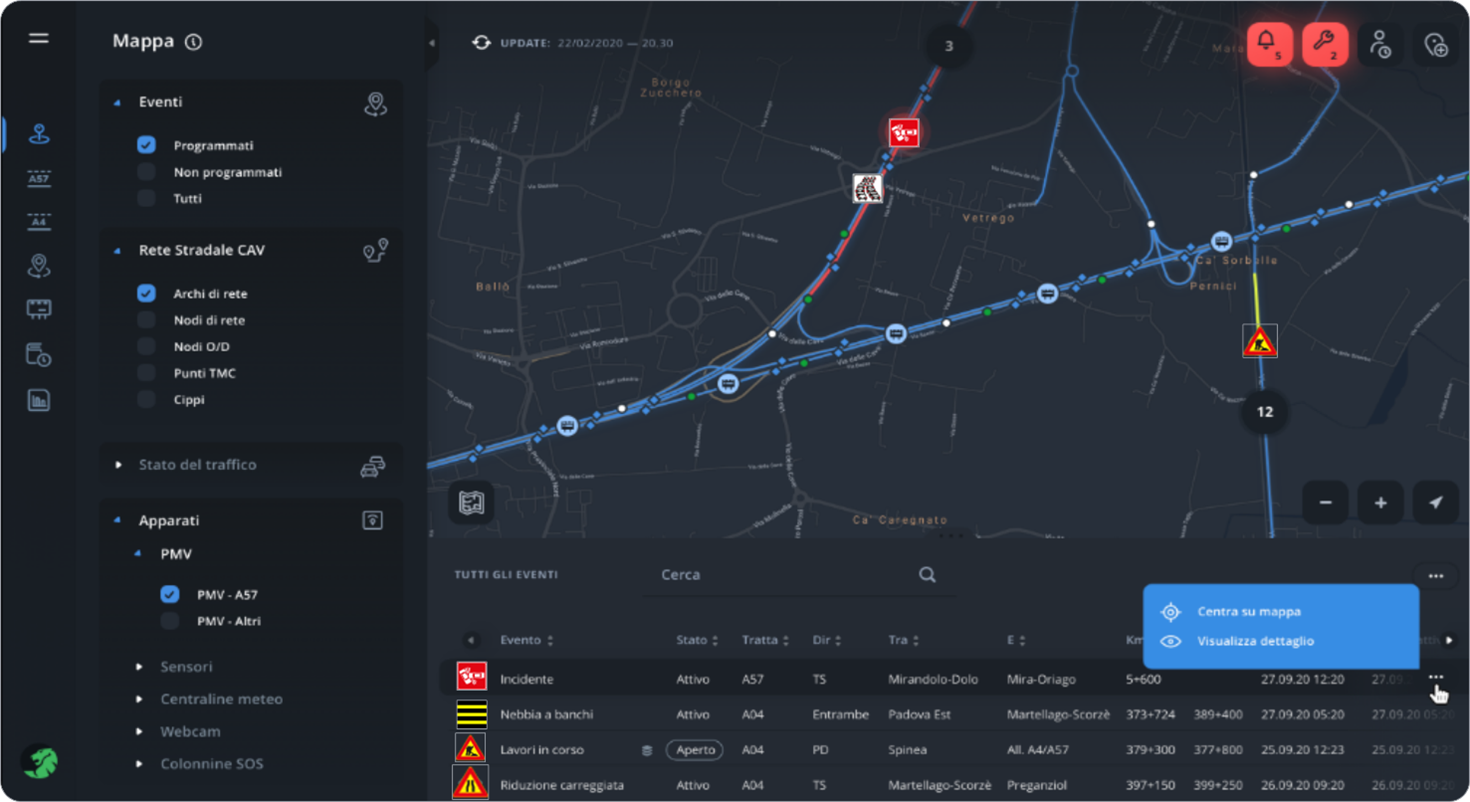
A better traffic management, in timing and efficiency, is expected, with immediate impacts on safety, congestion and consequently also on environment. In a pre-feasibility study this target has been evaluated as achievable with the planned implementation, while the final results should contribute positively to the entire Meridian action evaluation. At the end of the project we are engaged to provide the Meridian Project Management all the data requested for such evaluation.
Trento is the largest city of the Autonomous Province of Trento and daily attracts thousands of citizens that move through and within the city area. Moreover, the territory of Trento is a crucial node in the Brenner Corridor for foreign and national tourists heading towards regional and national tourist destinations.
Traffic monitoring is thus an important task for the Municipality of Trento, which boasts a long experience in both traffic monitoring and video surveillance systems. However, its traffic monitoring platform currently does not allow the integration nor the distribution of data with other territorial entities. Moreover, some important municipality roads are currently still not or poorly monitored.
In the framework of the MERIDIAN project the Municipality will thus sensibly extend its traffic monitoring capacity by means of new video sensors. Such sensors will be capable of counting and classifying vehicles, and detecting traffic congestion. An upgrade of the existing system based on inductive loops will also be carried out.
In order to support the new video sensors deployed during the project, the whole video surveillance platform will be updated. Moreover, the municipal fibre optic network will be extended in order to improve the connectivity or cover new areas mainly in the eastern hills of the city in correspondence with new sensors.
The real time data provided by new and upgraded sensors will be made available to the other project partners, in particular to the regional partners (Autonomous Province of Trento, Autonomous Province of Bolzano and Brenner Highway). This will allow significant synergies along the so-called Digital Green Brenner Corridor and will guarantee added value to the information that, in cooperation with the activities carried out by the other partners, will be distributed to users of the road network with the aim of optimising traffic levels and travel times.
Trento is the largest city of the Autonomous Province of Trento and daily attracts thousands of citizens that move through and within the city area. Moreover, the territory of Trento is a crucial node in the Brenner Corridor for foreign and national tourists heading towards Lake Garda and Italian seaside destinations in summer, and alpine valleys in both summer and winter.
Traffic monitoring is thus an important task for the Municipality of Trento, which boasts a long experience in both traffic monitoring and video surveillance systems. However, its traffic monitoring platform currently does not allow the integration nor the distribution of data with other territorial entities. Moreover, some important municipality roads are currently still not or poorly monitored.
The Steering Committee is formed by representatives from all MERIDIAN partners stated in the Grant Agreement. All beneficiaries and Affiliated Entities are committed to participate.
The MERIDIAN Steering Committee is the steering body of the project, in which decisions are made and technical harmonization is validated. Furthermore, the Steering Committee is the meeting to share knowledge between partners, present task results and discuss on relevant topics. The Steering Committee meets four times a year in one of the participation countries.
In the framework of the MERIDIAN project the Municipality aims at modernising and extending its traffic monitoring infrastructure both to improve its geographical coverage, in particular on the eastern hills of the city, and to allow the sharing of traffic data to its regional partners. This will be achieved by installing new video traffic sensors, connected to the main municipality data network by means of fibre optic links. The new video sensors will be capable of counting and classifying vehicles, and detecting traffic congestion. A general upgrade of the existing monitoring system based on inductive loops will also be carried out. The extension and upgrade of the monitoring network will thus allow for greater capillarity of detection and a better level of quality and completeness of information.
In order to support the new video sensors deployed during the project, the whole video surveillance platform of the city will be updated. This will enable the integration between video surveillance and traffic monitoring, e.g., allowing real time alarms related to traffic jams triggering the visualisation of the relative video streams. This is currently not possible with the softwares in use and will greatly improve the knowledge of the traffic status in real time. As a result, the management of both ordinary traffic and possible unexpected events by the staff of the municipality will be optimised.
Besides the benefits strictly related to the daily management of the city, the real time data provided by new and upgraded sensors will be made available also to the other project partners, in particular to the regional partners (Autonomous Province of Trento, Autonomous Province of Bolzano and Brenner Highway). This will allow significant synergies along the so-called Digital Green Brenner Corridor and will guarantee added value to the information that, in cooperation with the tasks that will be carried out by the other project partners, will be distributed to users of the road network with the aim of optimising traffic levels and travel times.
The project schedule is as follows:
The objective of the project is the digitalization of the arterial roads in the Bolzano Province that are strategically connected to the Brenner corridor. The road network has an interregional cross-border relevance because it feeds and receives the mobility fluxes to and from the corridor. Monitoring traffic flows through digital systems, in particular cameras, allows the generation of information about traffic around the corridor, information of all involved actors, and prediction of flows. Through a centralized mobility software, the cross-referenced information will allow accurate monitoring of traffic flows to formulate common strategies particularly to avoid heavy duty traffic and the consequent emissions on the arterial road network. The investment will allow the centralization of all road traffic data along the corridor in the provincial territory and cross-referencing them with data generated by the other road operators in a joint data-based management system that enables a coordinated, coherent management of the corridor, considering not only the needs of the TEN-T core network, but also the local road networks across the corridor.
Basing on the generated information, it will be possible to plan traffic restrictions or regulation according to the code; the system can be interfaced with the national SCNTT system of the forces of order.
Based on the information collected, roadworks can be organized even better in the future and targeted mobility concepts can be developed. The data show where traffic on the road is particularly dense, where information points or interventions are still needed to better guide the flow of traffic and, above all, where there is potential for shifting traffic to public transport. In this way, traffic flow, air pollution and noise emissions can be reduced and our sensitive landscape can be protected.
The Steering Committee is formed by representatives from all MERIDIAN partners stated in the Grant Agreement. All beneficiaries and Affiliated Entities are committed to participate.
The MERIDIAN Steering Committee is the steering body of the project, in which decisions are made and technical harmonization is validated. Furthermore, the Steering Committee is the meeting to share knowledge between partners, present task results and discuss on relevant topics. The Steering Committee meets four times a year in one of the participation countries.
The project will enable the exchange of information in a sensitive cross-border area. The main objective is to create a more efficient, interconnected, and multimodal network and infrastructure.
Based on the data, strategic interventions will be decided in order to encourage the world population to use public transport more, by adapting the offer as well. The traffic flow must be reduced so that there are fewer vehicles on our roads. The safety of our own population must be increased and the use of fossil fuel, air pollution and noise levels reduced.
The municipalities and the law enforcement agencies use the same technology to facilitate their work in terms of security. On the basis of an agreement, our cameras are also used by them, and the data will be interrogated in unencrypted form, within the limits of the law and the data protection authority. In return, the data from their systems, which are positioned on municipal roads, will be transmitted to our statistical software in encrypted form. Thanks to this agreement, the institutions don’t have to buy and install their own additional traffic reading cameras, where another institution has already installed or will install one, with the result that public monies are not spent twice. The number of cameras is reduced, since in the same location one camera is sufficient for all, with the consequence that resources are also used efficiently.
By the end of 2025, about 500 such cameras will be installed, which will send data to our statistical software. This will make it possible to analyze and understand the traffic flow in ever greater detail.
The purpose is the will to optimize the existing road traffic network
We want to reach the target, working in 3 different chapters.
1) Chapter 1: we want to built a dense network of sensors to permit us to know the traffic situation in real time, for all the core corridors of the country.
2) Chapter 2: we want to achieve ad manage data
3) Chapter 3: the third part consist in building an “user interface” for sharing data and information to our system-partners, for the optimization of the road traffic network
NETWORK CONSTRUCTION
We want to built the “core information system” using two different kind of sensors in a basic network of (about) 135 gates:
1) The old and solid technology given by loops and counters, that is still perfect for a very accurate classification of vehicles
2) The new technology of “smart cameras”, that read and (and encrypt) plates of vehicles, that is very good and chip for reading plates
Linking these two technologies, in these gates we have the maximum results, because a class can be linked forever with the plate. So, if in many others gates, the network is only provided by smart cameras, the class is obtained “via software” because the link was already obtained in one of the gates of basic network
SOFTWARE
We built a software that uses all the most important algorithms taken from Highway Capacity Manual, arriving to achieve the Level of Service of the most important arcs of the country, managing data either to achieve real time information, or to obtain statistic data.
So, for each core road we have:
Trave time, Flow, Density, Peek hour traffic, average speed, LOS, about global flow but also particular classes of traffic as:
Commuter traffic,
Freight traffic,
Touristic traffic,
Motorbike traffic
……
And so, we can fill moment by moment, our accurate origin/destination matrix.
USER INTERFACE
We build a “user system interface” to permit to our system partners to read, use and manage data obtained by software processing.
A part of data will consist in images and screenshots downloadable from system server; another part of data will consist in alphanumeric strings that can be managed and processed by our partner-users
This project happens because there is the will to update and modernize the Trentino traffic monitoring network and to make it functional to the changed needs of the Provincia Autonoma di Trento.
The existing network uses only loops and doesn’t permit to obtain O/D matrixes in real time.
This project increases this monitoring network and build the “core information system”. This system in the future could be improved using only smart cameras, because the basis for the right and accurate classification is already done.
The Steering Committee is formed by representatives from all MERIDIAN partners stated in the Grant Agreement. All beneficiaries and Affiliated Entities are committed to participate.
The MERIDIAN Steering Committee is the steering body of the project, in which decisions are made and technical harmonization is validated. Furthermore, the Steering Committee is the meeting to share knowledge between partners, present task results and discuss on relevant topics. The Steering Committee meets four times a year in one of the participation countries.

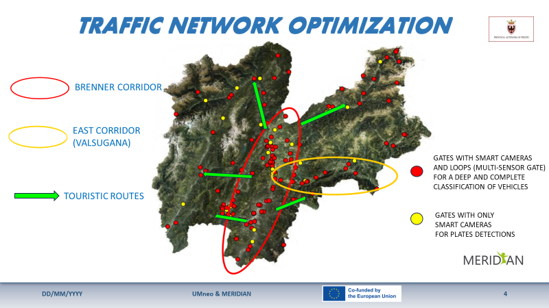
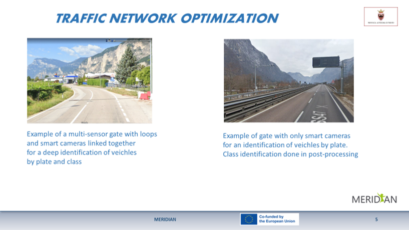
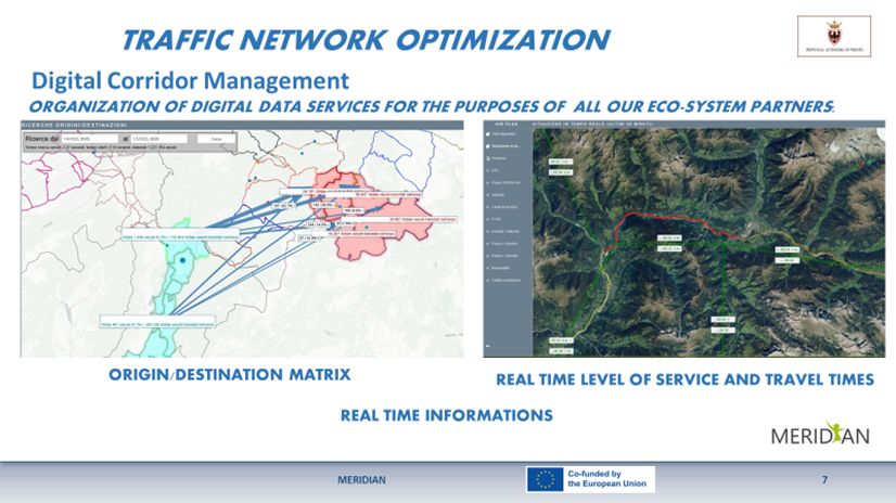
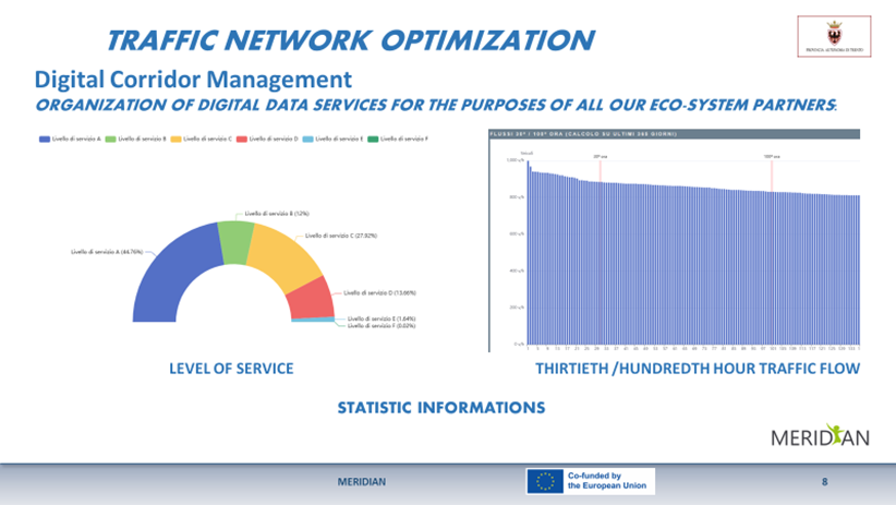
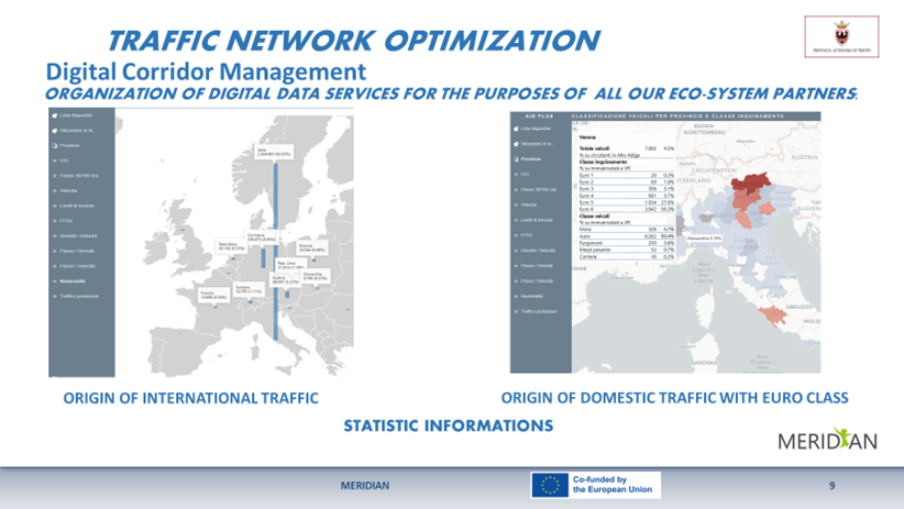
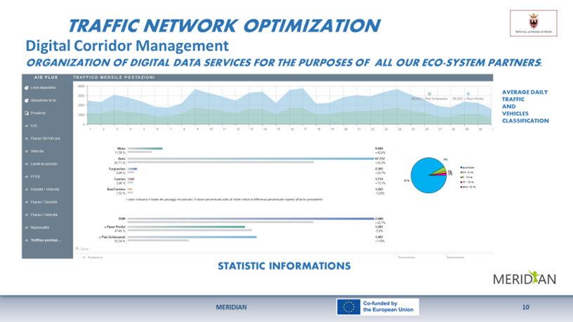
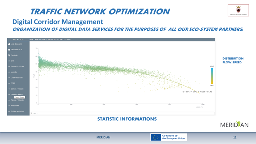
Expected results concern two different chapters:
Our Department, with this project, is applying to become the information traffic provider, for all the institutional partners of P.A.T (Provincia Autonoma di Trento).
Furthermore, for the increase of the “sensor network”, we expect that all the new smart cameras bought in Trentino by any public enduser (expecially municipalities) will have to be entered in this digital data system.
So, since all the acquired data will be managed by this software, linking plates with vehicle classification, the result of this kind of working progress, will be a continuous improvement of traffic system analysis.
Anyway, we wait the best results by the action of our institutional partners, that receive and uses our data. We wait:
VIAGGIARE IN TRENTINO is a service for collecting and sharing information on disturbances to road traffic that may result in congestion or slowdowns of traffic on the road network of the province of Trento. Information is shared with road users through
With the tender for the three-year period 2023-2026, the Autonomous Province of Trento wants to enhance the current format of “Viaggiare in Trentino” with the following implementations:
The Steering Committee is formed by representatives from all MERIDIAN partners stated in the Grant Agreement. All beneficiaries and Affiliated Entities are committed to participate.
The MERIDIAN Steering Committee is the steering body of the project, in which decisions are made and technical harmonization is validated. Furthermore, the Steering Committee is the meeting to share knowledge between partners, present task results and discuss on relevant topics. The Steering Committee meets four times a year in one of the participation countries.
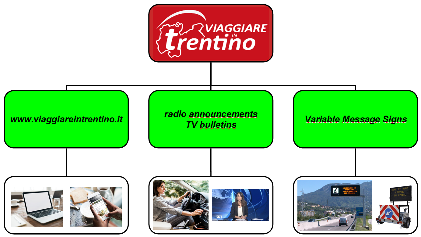
What are the objectives and results expected with the new format of “Viaggiare in Trentino“?
MobiData BW is the central and state-wide open mobility data platform of Baden-Wuerttemberg, which is developed and operated by the state-owned NVBW – Nahverkehrsgesellschaft Baden-Württemberg mbH. MobiData BW provides free and non-discriminatory access to mobility data across all transport modes for the public, such as real-time data on public transit, road and parking information, availabilities of sharing vehicles, or static data on mobility infrastructure and traffic counts.
The platform serves two underlying principles: data standardization and open data licensing. Therefore, MobiData BW is more than an open data portal listing different mobility data. By aggregating and harmonizing data from different data generators, MobiData BW transforms proprietary APIs and different data formats into approved standards, which reduces the obstacles to use mobility data for innovative digital mobility solutions.
MobiData BW collects, bundles, and harmonizes data on the state-level of Baden-Wuerttemberg and is connected to the German national access point for mobility data (NAP), called mobilithek. The infrastructure of MobiData BW therefore plays a significant role within the federal data sharing system in Germany, especially by supporting local authorities and transport companies fulfilling data sharing obligations and by enabling regional partners to start leveraging existing data assets through sharing it with the public.
The Steering Committee is formed by representatives from all MERIDIAN partners stated in the Grant Agreement. All beneficiaries and Affiliated Entities are committed to participate.
The MERIDIAN Steering Committee is the steering body of the project, in which decisions are made and technical harmonization is validated. Furthermore, the Steering Committee is the meeting to share knowledge between partners, present task results and discuss on relevant topics. The Steering Committee meets four times a year in one of the participation countries.

MobiData BW is designed as an open data platform serving an open innovation process with data generators and reusers from public authorities, start-ups, industry partners, mobility providers, public transport operators, universities, and citizens.
It is the aim of MobiData BW to stimulate a digital innovation ecosystem and to provide a basis for the development of mobility services that promote more sustainable and convenient mobility options for everyone. In 2024, the existing open data platform MobiData BW receives several technical updates, such as a new website and a new data integration platform which leads to a higher flexibility and a quicker integration of new data generators.
The federal state of Baden-Württemberg in the south of Germany is currently planning a Mobility Management Center (MMC) to enforce sustainable intermodal mobility by the implementation of integrated traffic management strategies on the basis of real time traffic information. Furthermore, 45 tunnels on federal and state roads will be centrally monitored.
Traffic infrastructure is opposed to a growing number of users. Beyond that, the transport sector faces the big challenge of decarbonisation. To increase the performance of the existing infrastructure and to enforce sustainable mobility, an intermodal and intelligent traffic control will be established. For this purpose, problems in traffic flow are identified and appropriate strategies are developed (e.g. signalization, recommendation to switch transport mode). The novel approach connects different stakeholders and does not focus on only one stakeholder, e.g. road authority.
The Steering Committee is formed by representatives from all MERIDIAN partners stated in the Grant Agreement. All beneficiaries and Affiliated Entities are committed to participate.
The MERIDIAN Steering Committee is the steering body of the project, in which decisions are made and technical harmonization is validated. Furthermore, the Steering Committee is the meeting to share knowledge between partners, present task results and discuss on relevant topics. The Steering Committee meets four times a year in one of the participation countries.
Modern and climate friendly mobility needs intelligent traffic flow management, which addresses all stakeholders and all modes of transport. The MMC aims to achieve these goals by establishing a platform for different stakeholders to plan and execute defined intermodal strategies. The MMC is scheduled to start in 2026.
Bayerninfo provides multiple data concerning traffic information. This includes real time data to generate congestion messages, notifications of dangerous situations, road works information, data on public transport and more. In addition, data on shared mobility services, electro-mobility and parking information is being integrated to Bayerninfo to ensure an even better user experience and to encourage multimodality. Furthermore, Bayerninfo contains information on freight transport i.e. data on truck parking spaces and data on freight traffic centers.
Already in the mid-90s, the Bavarian Road Administration has launched the internet traffic information service at www.bayerninfo.de. The systems have been extended over the years, new data sources have been integrated and new partners have been acquired. Bayerninfo now collects a comprehensive set of important traffic information for all means of transport, offers internet services and provides data for third party applications.
The Steering Committee is formed by representatives from all MERIDIAN partners stated in the Grant Agreement. All beneficiaries and Affiliated Entities are committed to participate.
The MERIDIAN Steering Committee is the steering body of the project, in which decisions are made and technical harmonization is validated. Furthermore, the Steering Committee is the meeting to share knowledge between partners, present task results and discuss on relevant topics. The Steering Committee meets four times a year in one of the participation countries.
The goal of Bayerninfo is the constant improvement of traffic information. Reliable traffic information can contribute to a better traffic situation. Due to the variety of integrated sources i.e. E-Scooter, public transport, multimodality along the route chain can be promoted. With the integration of charging stations and data on shared mobility, the latest developments in the field of mobility are addressed. Furthermore, Bayerninfo not only provides information for individual traffic but also for freight transport. Specifically by integrating the freight traffic centers, important information on freight traffic transshipment points is available.
Deadline for the integration of all data is December 2025.
The Activity will aim at improving the logistic process in the port area, with special attention to the improvement of the circulation of trucks along the access roads to the port area. Specific tools such as a system for tracking, counting and classification of vehicles will be installed along the access roads to the port to get data related to the traffic in the port area that will be connected to the booking system and to the Port Community System for the improvement of the logistic process management and for allowing the analysis of traffic flows of heavy-duty vehicles. The project will also develop a Data Lake where all the data coming from different systems and a Data Analytics system will be concentrated and used to support the decision-making process and the calculation of KPIs for the evaluation of the efficiency of the process. The two deployments within the activity will provide a better knowledge of the traffic volume along the network approaching the port and will allow to digitalize and speed up the checks on the goods. The first action will provide an understanding of which roads are more congested and give indications or suggest alternative routes to trucks approaching/leaving different terminals, thus rationalizing the traffic of trucks in the area and will allow the reduction of congestions for controls on the goods entering/exiting the port. The ITS tools deployed will therefore lead to increased road safety and improvement of the intermodality (sea – road) of goods at the port of Ravenna and consequently within the Mediterranean and Baltic-Adriatic TEN-T corridors.
The implementations will be carried out inside the Port of Ravenna, that is the only port of Emilia-Romagna region and 4th in Italy in terms of goods handled, reaching 27.4 million tonnes in 2022. In order to cater for the needs of the region, such volumes need to be handled efficiently. The quantity of goods passing through the port also mean high levels of traffic in the port area and congestion due to lengthy checks on the goods. This, in turn, can cause inconveniences and risks to other road users. By speeding up the checks, these risks can be avoided and the efficiency of the intermodal activities can be improved.
The Steering Committee is formed by representatives from all MERIDIAN partners stated in the Grant Agreement. All beneficiaries and Affiliated Entities are committed to participate.
The MERIDIAN Steering Committee is the steering body of the project, in which decisions are made and technical harmonization is validated. Furthermore, the Steering Committee is the meeting to share knowledge between partners, present task results and discuss on relevant topics. The Steering Committee meets four times a year in one of the participation countries.
The task will aim at improving the logistic process for goods in the port area, with special attention to the improvement of the circulation of trucks along the access roads to the port area. To serve that purpose, different solutions will be offered in the framework of the project:
The project is expected to result in increased knowledge regarding the traffic in the port area. This will lead to better management of traffic flows, which will benefit the intermodal (maritime – road) activities at the port of Ravenna and consequently within the Mediterranean and Baltic-Adriatic TEN-T corridors by making them more efficient. It is also expected to result in safer roads and decreased risk for other road users by reducing the congestion in the port area.
By the end of 2023, a call for tender will be published. The implementations will be carried out during 2024, leaving the last period of the project for testing.
Within the Meridian project, the aim of the project in the port of La Spezia is to implement an appointment system for trucks.
The appointment system will be focused on a reliable system which allows the digital exchange of information between the actors involved in the process.
To load/unload a container from a terminal in the port is a process currently managed by many actors (Port Authority, Terminal Operators, Customs, Health Authority etc.) and the harmonization of the different systems should be enhanced.
The system will be an integrated solution for collecting information about the availability of containers, digitally secured and fully integrated with the actual IT platforms owned by the Port Authority and tools at drivers’ disposal. The new solution is intended to speed up the process of releasing containers and make it safer and more efficient.
The Steering Committee is formed by representatives from all MERIDIAN partners stated in the Grant Agreement. All beneficiaries and Affiliated Entities are committed to participate.
The MERIDIAN Steering Committee is the steering body of the project, in which decisions are made and technical harmonization is validated. Furthermore, the Steering Committee is the meeting to share knowledge between partners, present task results and discuss on relevant topics. The Steering Committee meets four times a year in one of the participation countries.
This appointment system will reduce queues at the port entrance, contributing to the reduction of emissions in line with Green Ports Masterplan objective. This solution will be a neutral, central data platform that brings together all stakeholders involved in the container import/export process.
Integrated with the IT platform of the port community PCS in La Spezia, it will also be possible to monitor who took part in the container handling, improving the Level of Service (LoS) at the port entrance and in the whole process.
The task concerns the optimization of road transport flows into/out of the Ports of Trieste (core port) and Monfalcone (comprehensive port), both managed by the Port Network Authority of the Eastern Adriatic Sea. More specifically, the implementation will include the development of the port mobile app to manage such flows, which is already being developed in the framework of the FENIX “A European Federated Network of Information eXchange in LogistiX” project (2018-EU-TM-0077-S), co-funded by the CEF Programme, which finished in 2022.
The mobile app is fully integrated with and is able to allow access to several modules of the Port Community System (PCS), such as “port access”, “transit permits”, “gate automation” and “gate monitoring”.
New features of the app include slot booking, relieving transport peaks which create bottlenecks around the port and spreading the truck handling load equally.
This will be done in compliance with EU Reg. no. 1056/2020 on electronic freight transport information (eFTI).
The mobile app will also include the development of the DATEX interface, which was developed within the UMneo project (2016-EU-TM-0044-M), sharing traffic data of the neighbouring motorways with road hauliers and users of the Port of Trieste.
The app will also feature tracking and tracing of trucks to/from the Port of Trieste from neighbouring customs free areas and railroad terminals.
The Port Network Authority of the Eastern Adriatic Sea is a public body having as its primary task to direct, plan, coordinate, promote and control port operations and commercial and industrial activities in the ports of Trieste and Monfalcone, being respectively core and comprehensive nodes in the TEN-T network.
Located at the intersection between the Baltic-Adriatic and Mediterranean TEN-T core network corridors, the Port of Trieste is an international hub for overland and sea trade with the dynamic markets of Central and Eastern Europe, and it is the top-ranking Italian port for total throughout, with more than 57 million tons (2022) as well as for intermodal trains – almost 10,000 trains.
The Port Network Authority of the Eastern Adriatic Sea is a member of the North Adriatic Port Association (NAPA), which has the goal of promoting the Northern Adriatic route as an alternative to the North-European ports and the development of maritime and hinterland connections, environmental protection, safety and information technology.
For all the reasons listed above and the numbers of traffic the Port Network Authority of the Eastern Adriatic Sea has to manage, the task developed within MERIDIAN will make entry/exit in the Ports of Trieste and Monfalcone faster and more efficient, reducing traffic congestion and ultimately air pollution and GHGs.
The Steering Committee is formed by representatives from all MERIDIAN partners stated in the Grant Agreement. All beneficiaries and Affiliated Entities are committed to participate.
The MERIDIAN Steering Committee is the steering body of the project, in which decisions are made and technical harmonization is validated. Furthermore, the Steering Committee is the meeting to share knowledge between partners, present task results and discuss on relevant topics. The Steering Committee meets four times a year in one of the participation countries.
The task allows the optimization of entry/exit of trucks in the ports of Trieste and Monfalcone, improving the accessibility of core and comprehensive port nodes.
The main objective is to realize efficient, interconnected and multimodal networks and infrastructure.
The IT network of the Verona freight village is a project conceived by Consorzio ZAI in 1998 that has allowed to wire up the optical fibre in the entire area of the node.
After 25 years this infrastructure has to be renewed and improved because the needs of transport operators and IT services have been changed very quickly during these years.
Over the last 20 years, the infrastructure has turned out to be essential for the Verona freight village, especially for the technological progress and for the safety and security of the entire area. There is therefore a need to update the network with targeted interventions to satisfy the increasing demand of IT services requested by the players operating in the area.
The last improvement of this ICT infrastructure concerned an update of the backbone, new datacenters and server rooms together with a video surveillance system.
Within MERIDIAN Consorzio ZAI will complete this improvement in order to increase safety and security in data-exchange on the TEN-T corridors to improve the efficiency of the terminal operations. The foreseen activities are:
The IT network of the Verona freight village is a project conceived by Consorzio ZAI in 1998 that has allowed to wire up the optical fibre in the entire area of the node. The management and development of the network was assigned to the subsidiary called Quadrante Servizi that has fostered the innovation in the freight village system. The initial project foresaw a backbone Fast-Ethernet (100Mbps) of optical fibre, a server room placed inside the management centre, native services with an internet ISDNx2 connection, a WEB server and a MAIL server.
After 25 years this infrastructure has to be renewed and improved in order to face all new challenges in transport sector.
The Steering Committee is formed by representatives from all MERIDIAN partners stated in the Grant Agreement. All beneficiaries and Affiliated Entities are committed to participate.
The MERIDIAN Steering Committee is the steering body of the project, in which decisions are made and technical harmonization is validated. Furthermore, the Steering Committee is the meeting to share knowledge between partners, present task results and discuss on relevant topics. The Steering Committee meets four times a year in one of the participation countries.
The main objective is to increase safety and security in data-exchange on the TEN-T corridors to improve the efficiency of the terminal operations.
The results will be a completed improved ICT system able to satisfy all the new requests by transport and logistics operators